What You Need to Know on the 2020 US Olympic Marathon Trials Course — With Elevation Charts

By LetsRun.com
January 7, 2019
On Monday, the Atlanta Track Club and USATF unveiled the final course map for the 2020 US Olympic Marathon Trials, to be held in Atlanta on February 29, 2020. The loop course is designed to be spectator-friendly and highlight some of the attractions of Atlanta. It begins next to Centennial Olympic Park, in front of the College Football Hall of Fame, and consists of three 6-mile loops (on which runners will pass the Martin Luther King National Historical Park and the Margaret Mitchell House — author of Gone with the Wind), and one 8.2-mile loop, which runs by the Georgia State Capitol, the Olympic rings and cauldron from the 1996 Games, and Mercedes-Benz Stadium, home of the NFL’s Atlanta Falcons and site of next month’s Super Bowl LIII. The course finishes in Centennial Olympic Park.
In its press release, the Atlanta Track Club notes that while the course is a net downhill (17 feet), there will be approximately 1,000 feet of elevation gain during the race — a not insignificant amount. And based on LetsRun.com’s armchair analysis, they may actually be underselling it. We plotted the course on three apps that track elevation changes, and all three of those apps said that the elevation gain will be 1,500 feet or more. You can view the course maps we plotted (with elevation charts) below.
The race plans on releasing its own elevation map later.
Course maps (with elevation charts):
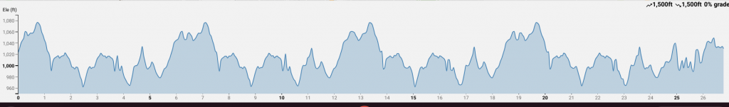 Elevation Chart from Onthegomap.com
*Strava *On the Go Map *Map My Run *Official course map (no elevation chart)
A couple of notes:
- We plotted the course released by ATC/USATF as best we could on each app, but it’s still an approximation. Each course we plotted came out to 26.8 miles, in part because there was no cutting of tangents.
- While the Strava and On the Go Map courses turned out fairly similarly, the Map My Run course produced a much greater difference between the lowest and highest points on the course (low of 965 feet, high of 1,314 feet) compared to Strava (low of 960, high of 1,078) and On the Go Map (low of 962, high of 1,076). Because of that, we’ll be focusing our analysis on the Strava/On the Go Map projections rather than the Map My Run projection.
Where are the hills?

While the course has a number of small climbs and descents throughout, there is one major climb and one major descent pointing out. Per Strava, the major climb begins on Edgewood Avenue at 5.1 miles, with the course climbing 82 feet over the next 0.8 of a mile, concluding on Marietta Street. The grade peaks at 4.2% at 5.6 miles.
For perspective, the Boston Marathon’s famed Heartbreak Hill climbs a similar amount (88 feet, according to Wikipedia) but does so more rapidly (that climb is completed in 0.4 of a mile, half the time it takes in Atlanta).
Of course, because this is a loop course, the runners at the Trials will make that climb three times in all — just after 5, 11, and 17 miles.
The climb comes near the end of each 6-mile loop. After they complete it, the runners will loop around on Marietta Street and after heading north onto Peachtree Street will encounter a fairly steep downhill just before the 1-, 7-, 13-, and 19-mile marks (they run it four times, as compared to the major climb, which is partially avoided on the final 8.2-mile loop). In this stretch, the runners will descend 82 feet over the course of 0.5 of a mile, with a steepest grade of -15.1% according to Strava.
How does it compare to past Olympic Marathon Trials courses?
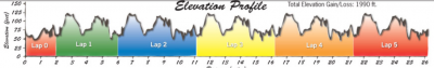 Elevation map of 2008 Men´s Trials from Mappery.com
The last two Olympic Marathon Trials, held in Houston and Los Angeles, were relatively flat. The 2008 Men’s Olympic Trials were held in New York on the rolling hills of Central Park. Looking at the elevation map for that race here, the Atlanta course has more elevation gain/loss than the New York Trials, but we don’t want to make any definitive comparison until more detailed maps are out. There definitely have been hillier courses for the Trials, as the 2000 Men’s Trials were held in Pittsburgh, which had very steep hills. And this course in Atlanta could be much hillier if it wanted to be. The Peachtree Road Race has a “Cardiac Hill” on it.
Full course map and video tour below:
https://www.youtube.com/watch?v=lX1QDIdJT74&feature=youtu.be